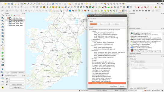
Last year we described a command line method that adds ESRI REST layers in QGIS. Well, a team at the Geometa Lab in the University of Applied Sciences Rapperswil (HSR) Switzerland, have released a plugin for QGIS that adds ESRI REST layers via a GUI (Github page). The plugin is experimental so you will need to tick the box “Show also experimental plugins” in the settings panel of the “Plugins – Manage and Install Plugins” dialogue in order to add the plugin to QGIS. The following URLs lists numerous REST layers in the plugin’s GUI:
http://services.arcgisonline.com/arcgis/rest/services
http://basemap.nationalmap.gov/arcgis/rest/services
http://services.nationalmap.gov/arcgis/rest/services
Reference:


Pingback: ArcGIS REST API Connector Plugin for QGIS | Geo-How-To News
Pingback: Adding ESRI’s Online World Imagery Dataset to QGIS | IeQGIS
I installed this plugin (QGIS 2.10.1). After installation I finally found the plugin in Vector > arcgiscon > arcgiscon. After starting the plugin, the user is requested to supply three items:
Layer URL
Layer Name
Filter
But there are no instructions on what to fill in for those three items. Very frustrating! Would you please help by giving an example? Thanks!
The plugin was updated, but it appears to be broken. Well I wasn’t able to figure out how to use the new version either. Here is the old version, unzip and place the folder in QGIS2 (the settings folder) – python – plugins.
Like Stu Smith I got nowhere with the current version. I’ve tried the older version as instructed by bbrhuft – this connects OK but the online services from ESRI no longer seem to provide high resolution aerial imagery.
The earlier python script which used to produce high resolution imagery for many months sadly seems to have been discontinued. The OpenLayer plugin which connects to Bing produces a serviceable aerial image (not as high a resolution as the earlier ESRI one) but a big problem is that it cannot be reprojected to a project’s EPGS (or at least it doesn’t for me).
Anyone any ideas how to get a similar aerial imagery as the earlier python scripts – or have we just been ‘too good to be true’ for the last few months?
I have Just tried to use the ArcGIS RST plugin and when I enter the one of the above URL listed I get the error message ‘the URL points not to a layer’ . Is any one having the same problem?
Finally deciding to go to the dark side and drop the coin on ESRIs products
Hi all Any news on how to get this plugin to show Arc maps ?
Hi, I’m the maintainer of the plugin. Following URLs should work:
http://services.nationalmap.gov/arcgis/rest/services/WFS/geonames/MapServer/2
http://services.nationalmap.gov/arcgis/rest/services/GlobalMap/GlobalMapWFS/MapServer/5
The URL must be a valid path to a “feature service” which can be verified by looking at the URLs above in a browser.
There is another caveat: The plugin will probably say that not all features of the layer could be loaded. That’s because the server does not support or enable paging (above servers show a “max. features” set to 1000.
In order to see more, you have to zoom in and right-click on layer, chosing reload in the menu entry of the plugin.
These layers can be added as WMTS layers
http://services.arcgisonline.com/arcgis/rest/services/ESRI_Imagery_World_2D/MapServer/WMTS/1.0.0/WMTSCapabilities.xml
http://services.arcgisonline.com/arcgis/rest/services/ESRI_StreetMap_World_2D/MapServer/WMTS/1.0.0/WMTSCapabilities.xml
http://services.arcgisonline.com/arcgis/rest/services/NatGeo_World_Map/MapServer/WMTS/1.0.0/WMTSCapabilities.xml
http://services.arcgisonline.com/arcgis/rest/services/NGS_Topo_US_2D/MapServer/WMTS/1.0.0/WMTSCapabilities.xml
http://services.arcgisonline.com/arcgis/rest/services/Ocean_Basemap/MapServer/WMTS/1.0.0/WMTSCapabilities.xml
http://services.arcgisonline.com/arcgis/rest/services/USA_Topo_Maps/MapServer/WMTS/1.0.0/WMTSCapabilities.xml
http://services.arcgisonline.com/arcgis/rest/services/World_Imagery/MapServer/WMTS/1.0.0/WMTSCapabilities.xml
http://services.arcgisonline.com/arcgis/rest/services/World_Physical_Map/MapServer/WMTS/1.0.0/WMTSCapabilities.xml
http://services.arcgisonline.com/arcgis/rest/services/World_Shaded_Relief/MapServer/WMTS/1.0.0/WMTSCapabilities.xml
http://services.arcgisonline.com/arcgis/rest/services/World_Street_Map/MapServer/WMTS/1.0.0/WMTSCapabilities.xml
http://services.arcgisonline.com/arcgis/rest/services/World_Terrain_Base/MapServer/WMTS/1.0.0/WMTSCapabilities.xml
http://services.arcgisonline.com/arcgis/rest/services/World_Topo_Map/MapServer/WMTS/1.0.0/WMTSCapabilities.xml